Uinta Highline Trail Guide: Everything You Need to Know!
The Uinta Highline Trail is a renowned backpacking route that traverses the entire length of the High Uintas Wilderness in northeastern Utah. Known for its stunning vistas, alpine terrain, and challenging paths, this trail is a bucket-list adventure for avid hikers. In this comprehensive guide, we will delve into every aspect of the Uinta Highline Trail, from planning your hike to tips for a successful journey. Whether you’re seeking detailed maps, shuttle information, or a well-rounded itinerary, you’ll find everything you need right here.
Overview of the Uinta Highline Trail
The Uinta Highline Trail stretches approximately 104 miles from McKee Draw in the east to the Highline Trailhead at Mirror Lake Highway in the west. This challenging trail typically takes around 7-10 days to complete, depending on your pace and experience level. The trail meanders through diverse landscapes, including dense forests, open meadows, rocky ridges, and high mountain passes.
Why Hike the Uinta Highline Trail?
Hiking the Uinta Highline Trail is a challenging but rewarding experience. The trail offers a sense of solitude and adventure, with fewer crowds than many other long-distance trails. It’s an opportunity to disconnect from the hustle and bustle of everyday life and reconnect with nature.
What is the Highline Trail in Utah?
The Uinta Highline Trail, often referred to simply as the Highline Trail, is one of the most scenic and challenging long-distance trails in Utah. It offers hikers the opportunity to experience the rugged beauty of the Uinta Mountains, the only major mountain range in the contiguous United States that runs east to west. The trail’s high elevation, ranging from 8,000 to over 13,000 feet, presents both breathtaking views and physical challenges.
Planning Your Hike
Proper planning is crucial for a successful hike on the Uinta Highline Trail. Here are the key elements to consider:
Best Time to Hike the Uinta Highline Trail
The best time to hike the Uinta Highline Trail is from late July to early September. During this period, the snow has mostly melted, and the weather is relatively stable. However, be prepared for sudden weather changes, including thunderstorms and cold nights.
How to Get There
To hike the Uinta Highline Trail, you’ll need to arrange transportation to the trailheads. The eastern trailhead is located at McKee Draw, near the town of Vernal, Utah. The western trailhead is at Hayden Pass, near the town of Kamas, Utah. Most hikers choose to start at the eastern trailhead and hike westward.
Uinta Highline Trail Map and Navigation
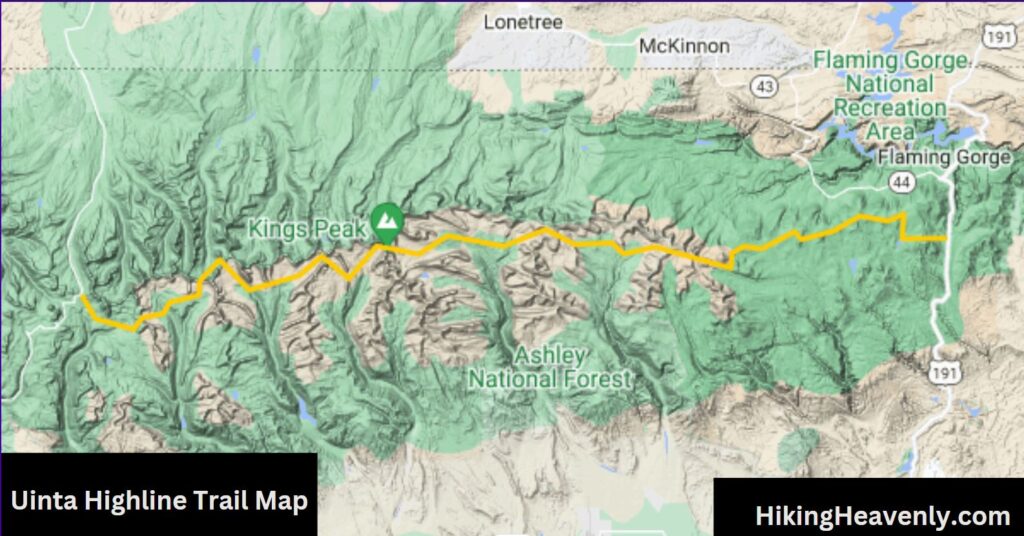
Having a detailed Uinta Highline Trail map is essential. You can find maps online or at local outdoor stores. Additionally, consider downloading a Uinta Highline Trail GPX file to your GPS device or smartphone for accurate navigation. These tools will help you stay on track and find water sources and campsites along the way.
Uinta Highline Trail Shuttle Services
Arranging transportation is a critical part of planning your hike. Since the trail is a point-to-point route, you will need to arrange a shuttle service to either drop you off at the starting point or pick you up at the end. Several local shuttle companies offer services for Uinta Highline Trail hikers. Booking your shuttle in advance is highly recommended, especially during peak hiking season.
Uinta Highline Trail GPX
Downloading a GPX file of the Uinta Highline Trail can be extremely helpful. GPX files provide detailed GPS data that can be used with various GPS devices and smartphone apps. This data will help you navigate the trail more accurately and avoid getting lost.
Uinta Highline Trail Itinerary
Creating a well-thought-out itinerary can make your hike more enjoyable and manageable. Here’s a sample 7-day itinerary for the Uinta Highline Trail:
- Day 1: McKee Draw to Leidy Peak (13 miles)
- Day 2: Leidy Peak to Dead Horse Lake (14 miles)
- Day 3: Dead Horse Lake to Lambert Meadow (15 miles)
- Day 4: Lambert Meadow to Anderson Pass (12 miles)
- Day 5: Anderson Pass to Porcupine Pass (15 miles)
- Day 6: Porcupine Pass to Painter Basin (14 miles)
- Day 7: Painter Basin to Mirror Lake Highway (21 miles)
This itinerary covers the major sections of the trail and includes recommended campsites. Adjust the daily mileage based on your fitness level and hiking experience.
Preparing for the Hike
Preparation is key to a successful Uinta Highline Trail hike. Here are some tips to help you get ready:
Physical Conditioning
The Uinta Highline Trail is a strenuous hike that requires a high level of physical fitness. Start training several months in advance by hiking with a loaded backpack, increasing your mileage and elevation gain gradually. Cardiovascular exercises, strength training, and flexibility exercises are also beneficial.
Gear and Equipment
Having the right gear is essential for your safety and comfort. Here’s a list of essential items:
- Backpack: A sturdy, comfortable backpack with a capacity of 60-70 liters.
- Tent: A lightweight, durable tent suitable for alpine conditions.
- Sleeping Bag: A warm sleeping bag rated for temperatures down to 20°F.
- Clothing: Layered clothing, including moisture-wicking base layers, insulating mid-layers, and a waterproof outer layer.
- Footwear: Sturdy, broken-in hiking boots with good ankle support.
- Navigation Tools: Uinta Highline Trail map, compass, and GPS device with Uinta Highline Trail GPX loaded.
- Food and Water: High-calorie, lightweight food, and a reliable water filtration system.
- First Aid Kit: A comprehensive first aid kit with supplies for blisters, cuts, and other common injuries.
Safety Considerations
Safety should be your top priority on the Uinta Highline Trail. Here are some tips to ensure a safe hike:
- Weather Awareness: Monitor the weather forecast and be prepared for sudden changes. Thunderstorms are common in the afternoons.
- Altitude Sickness: Acclimate to the high altitude gradually to avoid altitude sickness. Stay hydrated and take it slow in the first few days.
- Wildlife Encounters: Be aware of wildlife, including bears and mountain lions. Store your food securely and follow Leave No Trace principles.
- Trail Conditions: Check trail conditions before your hike. Snow and fallen trees can make the trail more challenging.
Hiking the Uinta Highline Trail
Once you’re on the trail, it’s important to pace yourself and enjoy the journey. Here are some tips for hiking the Uinta Highline Trail:
Trail Etiquette
Practicing good trail etiquette ensures a positive experience for everyone:
- Yielding: Yield to uphill hikers and give way to faster hikers.
- Leave No Trace: Pack out all trash, avoid damaging vegetation, and camp in designated areas.
- Respect Wildlife: Observe animals from a distance and never feed them.
Managing Water and Food
Water sources are relatively abundant on the Uinta Highline Trail, but it’s still important to plan your water stops. Use a reliable water filtration system to purify water from streams and lakes.
For food, pack high-calorie, non-perishable items. Plan your meals to ensure you have enough energy for each day’s hike. Dehydrated meals, nuts, energy bars, and trail mix are great options.
Coping with Altitude
The high altitude of the Uinta Highline Trail can affect even experienced hikers. To cope with altitude:
- Ascend Gradually: If possible, spend a day or two at a moderate altitude before starting your hike.
- Stay Hydrated: Drink plenty of water to help your body adjust to the altitude.
- Monitor Symptoms: Be aware of symptoms of altitude sickness, such as headaches, nausea, and dizziness. Descend to a lower elevation if symptoms worsen.
Enjoying the Scenery
The Uinta Highline Trail offers some of the most stunning scenery in Utah. Take time to enjoy the breathtaking views, wildflowers, and wildlife. The trail passes several notable landmarks, including King’s Peak, the highest point in Utah.
Uinta Highline Trail FKT
For those seeking an extra challenge, attempting the Fastest Known Time (FKT) on the Uinta Highline Trail is an option. The current FKT records are held by accomplished trail runners and are extremely challenging to beat. If you’re considering an FKT attempt, ensure you’re well-prepared and aware of the trail conditions and weather forecasts.
Trail Highlights
Leidy Peak
Leidy Peak is one of the first major landmarks on the trail. The peak offers stunning views of the surrounding mountains and valleys. It’s a great place to take a break and soak in the scenery.
Dead Horse Lake
Dead Horse Lake is a beautiful alpine lake located along the trail. The lake is surrounded by rugged peaks and offers excellent camping spots. It’s a perfect place to rest and enjoy the tranquility of the wilderness.
Anderson Pass
Anderson Pass is one of the highest points on the Uinta Highline Trail. The pass offers panoramic views of the Uinta Mountains and is a challenging but rewarding part of the hike.
Kings Peak
Kings Peak is the highest point in Utah and a popular side trip for hikers on the Uinta Highline Trail. Reaching the summit requires a strenuous climb, but the views from the top are worth the effort.
Tips for a Successful Hike
Prepare for High Elevation
The Uinta Highline Trail reaches elevations above 12,000 feet, so it’s essential to be prepared for high-altitude hiking. Take time to acclimate before your hike and stay hydrated to reduce the risk of altitude sickness.
Pack Smart
Pack light but make sure you have all the essentials, including a reliable tent, sleeping bag, cooking gear, and food. Bring layers to stay warm in changing weather conditions, and carry a good supply of water or a reliable water filter.
Stay Safe
Safety should be your top priority on the trail. Let someone know your itinerary and expected return date. Carry a first aid kit, and be aware of potential hazards such as sudden weather changes, wildlife, and difficult terrain.
FAQs About the Uinta Highline Trail
To help you further, here are answers to some frequently asked questions:
What is the best time of year to hike the Uinta Highline Trail?
The best time to hike the Uinta Highline Trail is from late July to early September when the snow has mostly melted, and the weather is relatively stable.
How difficult is the Highline Trail in Glacier National Park?
The Highline Trail in Glacier National Park is a separate trail located in Montana. It is considered moderately difficult due to its elevation gain and exposed sections. It is not as long or as high in elevation as the Uinta Highline Trail.
What is the Highline Trail in Utah?
The Highline Trail in Utah, also known as the Uinta Highline Trail, is a challenging 104-mile trail that traverses the Uinta Mountains from east to west. It offers stunning alpine scenery and requires careful planning and preparation.
How long is the Highline Trail in Glacier?
The Highline Trail in Glacier National Park is approximately 11.8 miles long. It is a popular day hike known for its scenic views and wildlife sightings.
Conclusion
The Uinta Highline Trail is an incredible adventure that offers hikers a chance to experience the rugged beauty of the Uinta Mountains. With proper planning, preparation, and respect for the trail, you can embark on a memorable journey through one of Utah’s most stunning wilderness areas. Remember to use a Uinta Highline Trail map, arrange for a shuttle, follow a well-thought-out itinerary, and be prepared for the challenges of high-altitude hiking. Happy trails!
Also check out 10 Best Hiking Trails in Austin with Waterfalls
